Iran nuclear and military damage revealed after restricted satellite images released
Iran Nuclear and Military Damage Revealed After Restricted Satellite Images Released
Constantvpn.com – High-resolution satellite imagery, previously limited to a select few, has now provided a clearer picture of the damage inflicted on Iran’s military and nuclear facilities. Over 250,000 images, sourced from nearly 800 locations across the country, were made publicly accessible following a decision by Planet Labs, a prominent satellite imaging company, to lift restrictions. These images, which were initially withheld at the request of the U.S. government, offer an unprecedented glimpse into the impact of recent strikes targeting Iran’s strategic infrastructure.
Scope of the Imaging Release
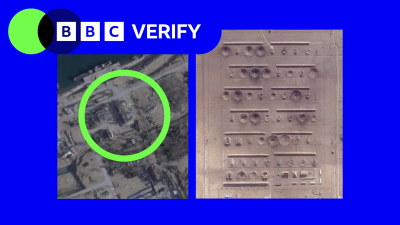
The newly available images span multiple regions, capturing a wide range of military installations and critical sites. Among the most scrutinized locations are Esfahan and Bushehr, where BBC Verify conducted a detailed analysis of the destruction. According to military intelligence firm Janes, the images reveal a variety of targets, including ammunition depots, ballistic missile systems, nuclear facilities, and surface-to-air missile sites. Additionally, naval bases and other key infrastructure have shown visible signs of damage.
While verified videos had previously confirmed attacks on these areas, the satellite images now provide a more granular view of the specific targets struck. This has allowed analysts to assess the scale of destruction and correlate it with reports from U.S. and Israeli military sources. The imagery also highlights the devastation at Bushehr, a coastal city, where several sites have been obliterated since March 9, when the restrictions were imposed. Structures such as military barracks, storage facilities, and hangars appear severely compromised, with some buildings entirely flattened.
Damage to Nuclear and Military Infrastructure
At Esfahan, home to two nuclear complexes, the impact on military infrastructure is equally severe. Janes reports that buildings at a key airbase, identified as Shekari 8, show extensive damage, particularly in areas designated for ammunition storage. More than 60 structures have been destroyed or heavily damaged at a military base located in the southern part of the city, while an additional dozen were hit at a site further south, near Baharestan. The destruction includes runways, aircraft, and equipment, with some craters still visible in the Bushehr International Airport’s runway despite repairs.
Not all damage is limited to land-based facilities. The images also capture the aftermath of attacks on naval installations, with destroyed vessels and sunken ships evident in several locations. These findings suggest a coordinated effort to target both Iran’s military and its nuclear capabilities, aiming to cripple its strategic assets. The severity of the damage has raised questions about the effectiveness of Iran’s defenses and the long-term consequences for its military operations.
Impact of Image Restrictions
Before the release of these images, the extent of the damage remained obscured due to the restrictions placed on Planet Labs’ data. This limitation hindered journalists, humanitarian organizations, and analysts from accurately assessing the impact of the U.S.-Israel strike campaign. Now, with access to the imagery, the true scale of the attacks is more visible, offering a critical resource for understanding the conflict’s consequences.
Planet Labs has maintained restrictions on its imagery across much of the Middle East, including Iraq, Lebanon, Israel, and Gaza. The company cited ongoing national security concerns and the need to protect personnel as reasons for this continued limitation. In the absence of Planet’s data, news outlets like the BBC and New York Times have turned to alternative satellite providers based outside the U.S. to continue their coverage. This shift underscores the importance of unrestricted access to satellite imagery in tracking conflicts and their aftermath.
Jeremy Binnie, a Middle East defense specialist at Janes, emphasized the significance of the newly released images. “The damage observed aligns with U.S. and Israeli reports of a broad strike campaign designed not only to neutralize immediate threats but also to weaken the infrastructure supporting Iran’s military operations,” Binnie stated. The analysis reveals that the attacks have targeted a range of facilities, from airbases to coastal military posts, indicating a strategic approach to disrupting Iran’s defense capabilities.
While the images provide valuable insights, they also highlight the challenges faced by those relying on satellite data to assess the conflict. The delay in image access has forced analysts to rely on partial information, making it difficult to gauge the full impact of the strikes. However, with the current release, the damage to both military and civilian infrastructure is now more tangible, offering a comprehensive view of the conflict’s reach.
As the situation in Iran continues to evolve, the newly available satellite images serve as a crucial tool for understanding the scope of the damage. The images not only document the physical destruction but also provide context for the strategic objectives behind the attacks. With further analysis, these visuals could help inform future assessments of Iran’s military readiness and the potential for recovery efforts.
Future Implications and Research Requests
Despite the progress in image access, the restrictions remain in place for many regions, prompting concerns about the transparency of the conflict. Analysts are now able to cross-reference the data with other sources, but the ongoing limitations could affect the accuracy of future assessments. The release of these images has already sparked discussions about the need for more open access to satellite data, especially in areas where the conflict is most intense.
As part of its ongoing efforts, BBC Verify invites the public to suggest areas of focus for future investigations. Whether it’s the resilience of Iran’s military infrastructure, the spread of damage to civilian areas, or the long-term strategic implications of the strikes, the images serve as a foundation for further inquiry. This initiative underscores the importance of continuous monitoring and the role of satellite imagery in shaping the narrative of the conflict.
